DE Online Desk:
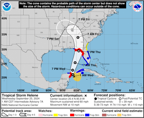
The Gulf Coast is bracing for a major hurricane landfall late this week as Tropical Storm Helene is forecast to rapidly intensify into a Category 3 storm on a path for the Florida coast.
Residents were already evacuating and filling sandbags Tuesday, two days before Helen’s expected landfall late on Thursday.
Florida Gov. Ron DeSantis expanded on Tuesday a state of emergency declaration to a total of 61 counties. The state has issued voluntary or mandatory evacuation orders for 13 counties.
- Advertisement -
Electric generators, emergency food and water supplies and search-and-rescue and power restoration teams were deployed by federal authorities as President Biden also declared an emergency in Florida.
Tropical storm warnings and hurricane watches were in effect early Wednesday for portions of western Cuba and Mexico’s Yucatan Peninsula as the storm strengthened and headed on a path to skirt the two countries.
Those with travel plans to Cancun, Playa del Carmen and Cozumel were urged to check with their carriers and consider altering their plans.
Helene was expected to accelerate toward the eastern Gulf Coast on Wednesday, trekking over record-warm water in the Gulf of Mexico that would act like jet fuel in intensifying the storm.
Brian McNoldy, senior research associate at the University of Miami Rosenstiel School of Marine, Atmospheric, and Earth Science, recently noted that ocean heat content in the Gulf of Mexico is the highest on record.
- Advertisement -
Warm water is a necessary ingredient to strengthen tropical systems.
Sea surface temperatures in the path of Helene are as warm as 89 degrees Fahrenheit — 2 to 4 degrees F above normal.
These record water temperatures have been made significantly more likely by human-caused climate change, according to Climate Central.
- Advertisement -
The North Atlantic Ocean as a whole has seen record warm temperatures in 2024, storing 90% of the excess heat from climate change produced by greenhouse gas pollution.
Helene Set to Rapidly Intensify Over Exceptionally Warm Waters and Favorable Conditions
In addition to record-warm waters fueled by climate change, Helene is expected to travel directly over the Loop Current, an area of exceptionally warm water that travels up from the Caribbean into the eastern Gulf of Mexico before squeezing through the Florida Straits and traveling northward as the Gulf Stream.
An otherwise favorable environment with high levels of storm-nurturing moisture and low levels of storm-killing wind shear mean that there is high confidence that
Helene will be the third of four landfalling U.S. hurricanes so far this year to rapidly intensify. Rapid intensification criteria is met when a storm gains at least 35 mph wind speed in 24 hours or less.
Official projections from the National Hurricane Center call for Helene to become a devastating Category 3 hurricane with peak sustained winds of 115 mph at landfall.
In the hardest-hit coastline communities, well-built framed homes may incur major damage or removal of roof decking. Many trees will be snapped or uprooted, blocking roadways.
Electricity and water will likely be unavailable for several days to even weeks after the storm passes.
Residents on the west coast of Florida were urged to heed evacuation notices from local officials and encouraged not to focus just on the center line of the forecast track.
Hurricane Helene will be a large, fast-moving storm with impacts that extend well away from the center, especially on the storm’s east side.
Communities from the Florida Keys north to Tampa could experience destructive storm surge flooding, even if the center of Helene remains farther west.
National Hurricane Center forecasters expect the size of the hurricane to be in the 90th percentile for that region, meaning an exceptionally large area will be impacted by flooding rain, storm surge and damaging wind.
The Gulf Coast of Florida is especially susceptible to storm surge flooding from hurricanes due to the shallow waters and shape of the coastline.


